Napoleon - An Intimate Portrait


Map of St. Helena Island

Map of St. Helena Island

- 17th century

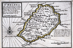
Used as a watering stop for East India Company ships and as a location from which the Royal Navy could dominate the South Atlantic, St. Helena was a mountainous tropical island a mere 28 miles in circumference. The nearest land, the west coast of Africa, was 1,140 miles away. A “buoy lost in the South Atlantic,” it was hell on earth for a man of Napoléon’s active temperament.

Historical Provenance - Ink on paper


Pair of 19th C. Chargers, Napoleon Bonaparte, battles of Jena & Wagram picture

Pair of 19th C. Chargers, Napoleon Bonaparte, battles of Jena & Wagram

$2950.00


PAIR antique french oil canvas napoleon battle scene painting rare 19thc picture

PAIR antique french oil canvas napoleon battle scene painting rare 19thc

$2275.00


Circa 1720 France Epee Sword King Louis XV Musketeer Napoleon Battle War picture

Circa 1720 France Epee Sword King Louis XV Musketeer Napoleon Battle War

$1397.00


French Napoleonic Belgian Discharge Certificate Battle of Austerlitz picture

French Napoleonic Belgian Discharge Certificate Battle of Austerlitz

$1000.00


Circa 1815 2nd Empire French Lion Head Epee Sword MOP Grip Napoleon Battle War picture

Circa 1815 2nd Empire French Lion Head Epee Sword MOP Grip Napoleon Battle War

$897.00


19th C Gilt Bronze French Officer Epee Sword Gilt Bronze Napoleon Battle War picture

19th C Gilt Bronze French Officer Epee Sword Gilt Bronze Napoleon Battle War

$897.97


Images © photo12.com-Pierre-Jean Chalençon
A Traveling Exhibition from Russell Etling Company (c) 2011