|

On eBay Now...
1870 Map| Outlines of tracts of land within which the city of Washington was lai For Sale

When you click on links to various merchants on this site and make a purchase, this can result in this site earning a commission. Affiliate programs and affiliations include, but are not limited to, the eBay Partner Network.

1870 Map| Outlines of tracts of land within which the city of Washington was lai:
$34.99
Map Size: 16 inches x 24 inches | Fits 16x24 size frame | Frame not included | Archival Quality Reproduction | 1870 Map|Title: Outlines of tracts of land within which the city of Washington was laid out|Subject: District of Columbia|Gas Street Lamps|Real Property|Rosslyn|Rosslyn Arlington, D.C. Notes: Also covers Rosslyn (Va.). Shows block and ward numbers, major buildings, block dimensions, street railroads, sewers, and streetlamps. Land tracts ca. 1792 shown by red pencilled lines. Depths shown by contours. "Entered according to Act of Congress ... in the year 1870." Includes notes and statistical table. assembled from small sheets, sectioned,Each Map is Hand Printed in our StudioFine Art Matte Paper (230g, 14mil) that maintains vivid colors and faithfulness to the original map.Archival inks guaranteed not to fade for 200+ yearsYour map will be shipped in a protective tube via first class mail
Powered by SixBit's eCommerce Solution
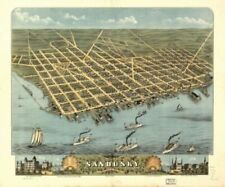
1870 Map| Bird's-eye-view of the city of Sandusky, Erie County, Ohio 1870| Ohio| $34.99

1870 Map| Van Vechten's map of Cook Du Page Countie's also the norther portion o $34.99

1870 Map - Town of Winchendon|Notes: Shows buildings and landowners. Pages 8-9 f $34.99
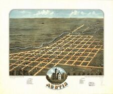
1870 Map| Bird's eye view of Austin, Mower County, Minnesota 1870| Austin|Austin $34.99
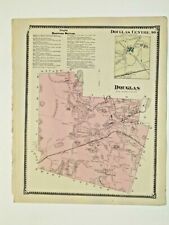
DOUGLAS, MA., VINTAGE HAND COLORED 1870 MAP., NOT A REPRINT $16.75
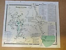
1870 BARRE CENTER, MA., MAP. $19.99

1870 Map| Battle field of Lexington, Mo., showing Map of earthwork defended by F $34.99

1870 Map| Henderson County| Henderson County|Henderson County Tex|Landowners|Rea $34.99
|


