|

On eBay Now...
1890 Map| Railroad map of Ohio published by the State. 1890. Prepared by J. A. N For Sale

When you click on links to various merchants on this site and make a purchase, this can result in this site earning a commission. Affiliate programs and affiliations include, but are not limited to, the eBay Partner Network.

1890 Map| Railroad map of Ohio published by the State. 1890. Prepared by J. A. N:
$34.99
Map Size: 24 inches x 24 inches | Fits 24x24 size frame | Frame not included | Archival Quality Reproduction | 1890 Map|Title: Railroad map of Ohio published by the State. 1890. Prepared by J. A. Norton, commissioner of railroads & telegraphs. Copyright by H. B. Stranahan|Subject: Ohio|Railroads|United States Notes: Scale ca. 1:600,000.Each Map is Hand Printed in our StudioFine Art Matte Paper (230g, 14mil) that maintains vivid colors and faithfulness to the original map.Archival inks guaranteed not to fade for 200+ yearsYour map will be shipped in a protective tube via first class mail
Powered by SixBit\'s eCommerce Solution

1890 SEPT SEATTLE LAKE SHORE & EASTERN RAILROAD ORIGINAL SYSTEM MAP WASHINGTON $49.99

1890 SEPT SOUTHERN PACIFIC RAILROAD ORIGINAL SYSTEM MAP TEXAS ARIZONA CALIFORNIA $49.99

1890 SEPT KENTUCKY UNION RAILROAD ORIGINAL SYSTEM MAP KU RR STATIONS HISTORY $49.99
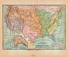
Antique 1890 Map Territorial Development of the United States 8x10 $13.56
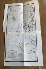
1890 Map, Rocky Mountain Region - Artisan Well Map, US Department of Agriculture $24.99
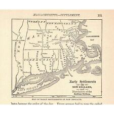
Circa 1890's Early Map Settlements in New England Victorian Engraving 2v1-76a $12.73
Norddeutscher Lloyd Breman Ship Line Map Germany- Galveston TX 1890s Map $124.95

Exquisite SARDEGNA Map. LARGE. (Orig. 1890, reprint 1972). $399.00
|


