|

On eBay Now...
1980 Map| Soil erodibility index map, Browns River Watershed, Chittenden, Frankl For Sale

When you click on links to various merchants on this site and make a purchase, this can result in this site earning a commission. Affiliate programs and affiliations include, but are not limited to, the eBay Partner Network.

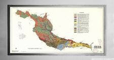
1980 Map| Soil erodibility index map, Browns River Watershed, Chittenden, Frankl:
$34.99
Map Size: 16 inches x 24 inches | Fits 16x24 size frame | Frame not included | Archival Quality Reproduction | 1980 Map|Title: Soil erodibility index map, Browns River Watershed, Chittenden, Franklin, and Lamoille Counties, Vermont|Subject: Browns River Watershed|Soil Erosion|Vermont Notes: September 1980. \"Source: USGS 1:100 00 base map of Chittenden Co., Vt., dated 1972, and USGS topo quads, 1:24 000 of Franklin and Lamoille Counties, Vt., dated 1948-1972.\" \"16,242.\"Each Map is Hand Printed in our StudioFine Art Matte Paper (230g, 14mil) that maintains vivid colors and faithfulness to the original map.Archival inks guaranteed not to fade for 200+ yearsYour map will be shipped in a protective tube via first class mail
Powered by SixBit\'s eCommerce Solution

Vintage Cedar Point Souviner Map 1980 $25.00

1980 GUIDE TO NAPA VALLEY WINERIES FOLDOUT BROCHURE & MAP ~ CALIFORNIA $2.99

STANFORD UNIVERSITY 1980 MAP $9.99

VINTAGE AFRICA MAP+ POLITICAL DEVELOPMENT National Geographic February 1980 $1.00

Vintage National Geographic Visitor's Guide To The Aztec World Mexico 1980 Map $4.99

THE PEOPLES OF CHINA MAP National Geographic July 1980 $1.50
1980 Map| General soil map, Des Moines River Basin, Iowa, Minnesota, and Missour $34.99

1980 Map| Merrimack County, New Hampshire| Merrimack County|Merrimack County N.H $34.99
|


